Where the Buffalo Roam… Again

Nov/Dec 2019: Canadian Wildlife Magazine

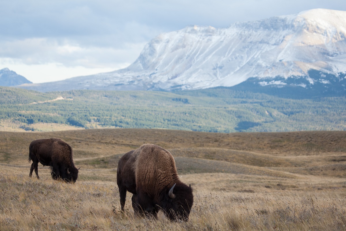
On a sunny day in August 2015, on the old Banff Indian Grounds near the bustling Banff townsite, with massive Cascade Mountain looming overhead, leaders of the Stoney Nakoda and Samson Cree First Nations gathered with other signatories of the Buffalo Treaty — marking their commitment to bring the buffalo back to landscapes that it hadn’t been in for more than a century and a half.

The location for this historic event was deeply symbolic. For thousands of years, First Nations congregated here to camp, trade and prepare for hunting forays. And to the south of the grounds sits diminutive Tunnel Mountain — just an easy peak to climb for some, but a sacred mountain for the Stoney Nakoda, who have formally requested changing its name to Sacred Buffalo Guardian Mountain, to honour their most revered animal instead of a train tunnel that was never actually built.

At the same time, in a remote section of Banff National Park some 60 kilometres past mountain ranges to the north, Parks Canada was kicking off its own historic bison restoration effort — a five-year, $6.4-million pilot project to bring the long-absent species back to the park. For a century, from 1897 to 1997, Parks Canada had kept some of the area’s last remaining bison close to the Banff Indian Grounds, protecting them in a 120-hectare paddock. North America’s largest land mammal, which had once dominated the western landscape with an estimated population of 30 million, had been relegated to a zoo-like display for tourists passing through.

Read the full story.

Can the Whitebark Pine Be Saved?

May 2019: Canadian Wildlife Magazine

After turning the corner on a remote mountain pass north of Glacier National Park, I stop to catch my breath and gaze upon the emerald waters of Ventego Lake — encircled by imposing mountains with Mordor-like names, including Sorcerer, Mystic and Iconoclast. The first thing that hits me is the fierce September wind, which funnels down through glacier-clad peaks and pummels the exposed lakeshore and hardy trees rooted there.

To get here, I have followed a team of ecologists along the aptly named “Heinous Traverse,” a trail that cuts across steep mountain slopes under hazardous rockfall. It leads us away from our temporary home at Sorcerer Lodge — a mecca for backcountry skiers that’s accessible only by helicopter.

These are the lengths ecologists will go to as they work to protect whitebark pine (Pinus albicaulis), an endangered species that grows high in the mountains of western North America. It is just one small part of a multi-year strategy to restore the trees throughout mountain parks. “It’s conservation at the ecosystem scale, which means we’re focused beyond park boundaries as well,” says Natalie Stafl, a senior Parks Canada ecologist who’s leading the restoration project for Mount Revelstoke and Glacier national parks. “We know what we need to do, and we know it’s possible. It’s just a matter of getting everyone working together to make it happen.”

Read the full story.

Wild Neighbours

May 2018: Canadian Wildlife Magazine

I stop my car on a windswept shoulder of the four-lane Trans Canada Highway a few kilometres west of where Alberta’s Bow and Kananaskis rivers converge – near Highway 40 to Kananaskis Country, and the exit to Highway 1A, the Bow Valley Trail. As a parade of cars and transport trucks speed by, I feel the ground shudder and shake. I park far off by the ditch and climb a sun-drenched hill. Looking east, there are rolling foothills that lead to Calgary an hour away; to the west, near and into the distance, there’s a seemingly impenetrable wall of mountains, carpeted green with spruce and pine, right up to jagged cliffs where trees no longer grow.

Everything gets pinched through a narrow gap between towering peaks – the converging highways, the towns and villages they connect, and the busy cross-country railway that transports goods to and from far-flung communities and ports on the coast. Wildlife habitat is wedged in here as well, strung along the gentler slopes, as animals try to follow their ancient pathways along the rivers.

The animals here, as everywhere, are constantly on the move, searching for food and mates and places to rear their young. That’s why the Alberta government is considering a wildlife overpass right where I’m standing – an area dubbed Bow Valley Gap by local conservationists – roughly 20 kilometres outside the Banff National Park gates. Proponents say the overpass would reduce the amount of wildlife-vehicle collisions that occur here, and would give roaming elk, wolves, grizzly bears and other animals safe passage across a highway that averages roughly 22,000 vehicles a day.

About 20,000 people live in the Bow Valley, mostly in Banff Townsite and nearby Canmore, and roughly four million tourists, nature lovers, hikers, skiers and back-country adventure seekers visit every year. “We’ve got two of the biggest protected areas in Alberta – Banff and Kananaskis – and a city of more than a million people an hour away,” says Jay Honeyman, a human wildlife conflict biologist for Alberta Environment and Parks. “It’s a very, very busy place – some say it’s pie-in-the-sky to think that wildlife would want to live here, but so far, they have.”

Read the full story…

What’s Upstream, Comes Down

September 2017: Up Here Magazine

The Mackenzie River stretches more than 1,700 kilometres and drains a 1.8-million-square-kilometre swath of land—a fifth of the country. It’s Canada’s largest watershed and the tenth largest in the world, and its main stem and tributaries form the natural highways that connect communities. They are the lifeblood of ecosystems that support people and wildlife throughout the North.

Dubbed the Cold Amazon, the largely intact Mackenzie watershed also helps to regulate Earth’s climate—as both a giant storehouse for carbon and a refrigerator through alternating seasons of ice cover and flowing water. Changes in the watershed affect the entire planet, and the people who live here say many climatic changes have already begun, including melting permafrost that triggers landslides and releases carbon from the previously frozen soil.

For the last century, a patchwork of land-use and management policies have been passed by towns, territories and provinces that often fail to account for the vast watershed’s interconnected features. Water used by British Columbia’s Peace Region’s hydroelectric dams and oil and gas projects, and Alberta’s oil sands, flows north through communities in the Northwest Territories, and eventually spills out across the Mackenzie Delta and into the Arctic Ocean. What happens upstream has major implications for those living downstream.

Read the full story…

Canada’s Great Trail

January 2017: Walrus and Canadian Geographic (Canada 150 Special Issue)

Think about nation-building projects in Canada, and one of your first thoughts is likely the transcontinental railway completed less than two decades after the country was born — a monumental effort that connected growing communities and industries across the nation.

When Canada turned 125, another ambitious project sought to further knit the country together. This time, a trail that would link our three oceans and celebrate the historic waterways, protected ecosystems and bustling towns and cities.

It may have seemed fanciful then, but today, as that dream turns 25 and the nation turns 150, the trail is about to be fully connected from coast to coast to coast — an achievement that’s being touted as one of the greatest gifts Canadians could share with each other and the rest of the world.

Read the full story…

The Lingering Legacy of the Nathan E. Stewart

April 2017: Hakai Magazine

In the waning light of November 14, 2016, the tugboat Nathan E. Stewart was finally lifted from the chilly water off British Columbia’s Athlone Island—32 days after it ran aground on its way south from Alaska.

When the tug struck the rocks on Edge Reef shortly after 1:00 a.m. on October 13, it was pushing a 10,000-tonne-capacity fuel barge. The barge was empty, but the tug still leaked about 110,000 liters of diesel and more than 2,200 liters of engine lubricants into the waters near Bella Bella, a town of 1,450 people in the traditional territory of the Heiltsuk First Nation. Strong winds and high tides pushed the fuel across Seaforth Channel and into Gale Creek, the site of an ancient Heiltsuk village, polluting critical marine habitats and harvesting sites.

“It was horrific—seeing the ocean full of diesel, and that sickening odor,” recalls Jordan Wilson, a Heiltsuk coastal guardian watchman, and one of the first on the scene. “All the hydraulic oils and engine oils—everything was just oozing out of that boat for weeks.”

With each tide, the toxins washed higher up on shorelines of surrounding islands. “That’s where I’d go to harvest food to share with my family and friends,” adds Wilson, “but not anymore.”

For many people outside the community, it was just another media story—a snapshot of a tragic event from a remote place. For locals, the spill lives on in myriad ways, with authorities still feeling the effects of a months-long drain on already strapped financial and human resources, and fishers unable to harvest manila clams and other species that may have been contaminated.

Read the full story…

In Search of the Wolverine

December 2016: Canadian Geographic

Wolverines are the essence of wilderness. High in the mountains, they lurk near avalanche paths and earn their Latin name, Gulo gulo (glutton), by gorging on half-buried animals and breaking bones with powerful jaws. They traverse deep snows with plate-sized feet and scale mountain summits so quickly it puts the world’s greatest human mountaineers to shame.

Although far from timid, wolverines are highly sensitive to human disturbance, says biologist Tony Clevenger, who’s been studying them in the Canadian Rockies for more than six years. “They’re big weasels with very fast metabolisms,” he says, “so they can’t just survive high up in the alpine on a rock; they also have to travel the valleys between those high passes.”

On a sunny day in March, I follow Clevenger into the backcountry northwest of Elkford, B.C. to check some bait traps he’d set up to hopefully attract, photograph (via motion-activated camera), and collect hair samples from passing wolverines.

It’s a non-invasive form of sampling; no animals are handled or harmed. By extracting DNA from the hair wolverines leave behind, Clevenger and fellow researchers hope to better understand these under-studied and elusive predators, and where they live and move throughout these mountain ecosystems.

Read the full story…

A Plan Comes Together

December 2015: Canadian Geographic

After flowing some 1,200 kilometres from Canada’s Rocky Mountains, collecting runoff from the Prairies and Boreal Plains, the Saskatchewan River spills into a maze of channels that cut across the low-lying forests and wetlands of the Saskatchewan River Delta.

At 10,000 hectares, it’s the largest inland delta in North America, and prime habitat for diverse wildlife, including one of the continent’s most important regions for migratory birds. It’s also part of Canada’s vast boreal forest, an ecosystem that stretches across the continent and soaks up so much carbon emissions it’s been called the northern lungs of the planet.

The delta and surrounding region in eastern Saskatchewan is one of several priority planning areas for the Canadian Boreal Forest Agreement (CBFA)—an ambitious pact signed in 2010 by six environmental groups and 18 forestry companies, the latter all members of the Forest Products Association of Canada.

Read the full story

Mapping the Wolverine Way

Winter 2015/16 issue: Highline Magazine

If you manage to haul a frozen, skinned beaver carcass up a remote mountain pass in the middle of winter, then nail it about two metres up a tree, you might just be lucky enough to attract a wolverine.

That’s what researchers have been trying to do for the past few years as part of a multi-year study to learn more about these elusive predators, and how they move and survive throughout the mountainous terrain of southern Alberta and British Columbia.

Led by Tony Clevenger, a biologist at Montana State University’s Western Transportation Institute, the research team tracks wolverines using non-invasive methods, such as cameras and hair traps (and, yes, skinned beavers on trees) with hopes of learning how these high-elevation predators are affected by highways and other barriers as they travel long distances in search of food and mates.

Read the full story at highlineonline.ca.